Distances and Heights are approximate.
Road directions are taken from Ordnance Survey 1:50000 First Series Maps - sheets 154, 155, 168., 169,
(C) Vernon Clarke, (1979)
Drawings by Joan Clarke
Map by John Walker
The Stour near Long Melford
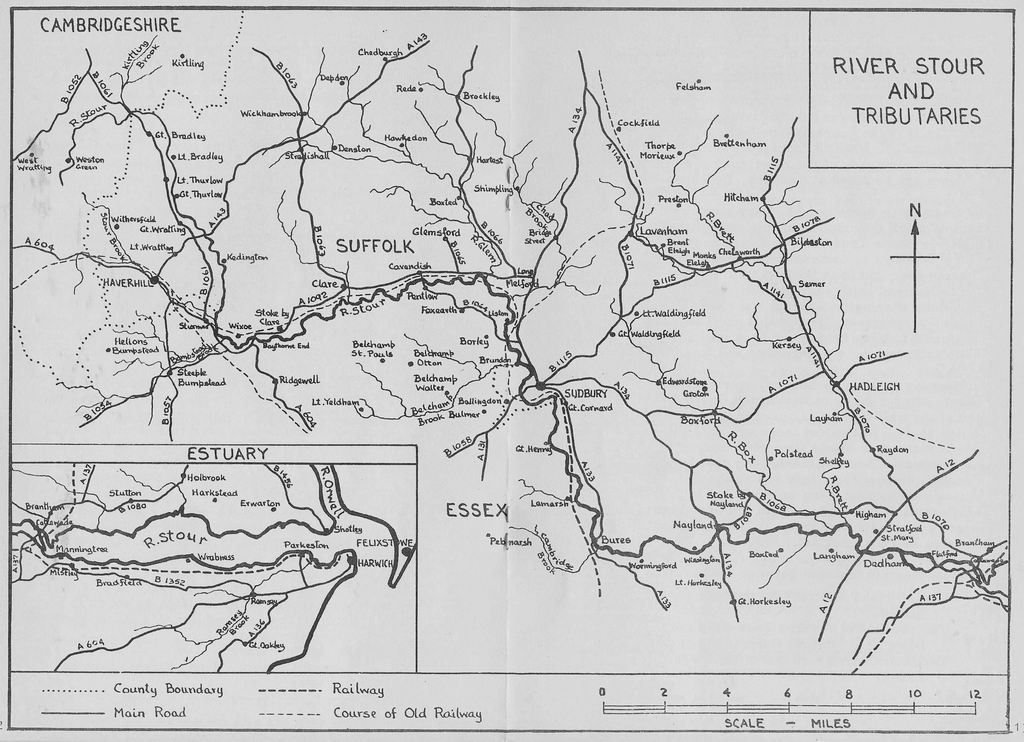
The East Anglian Stour, 13 miles shorter than the Stour of Somerset, Dorset and Hampshire and 2 miles longer than the Kentish Stour is 42 miles long. ("Stour" means "mighty river" so if we talk about "The River Stour" we are really saying "The River River".) It flows 4 miles in Cambridgeshire, 8 miles in Suffolk and then forms the border between Suffolk and Essex. The Anglian Water Authority figure for the length of the river from Sipsey Bridge (4 miles from the source) to Cattawade is 108.5 km (68 miles) including all meanders.
The Stour rises at about 380' above sea level and is 146' above sea level at Clare, 82' at Sudbury, 40' at Nayland, 27' at Stratford St. Mary and 13' at Flatford. It drops 190' in its first 10 miles and 40' in its last 10. There are gauging stations (weirs) for measuring the flow in the river at Kedington, West Mill (Glemsford), Lamarsh and Langham as well as on the 7 main tributaries just before their confluence with the main river.
The tributaries we mention (R = right bank, L = left) are:
| Kirtling Brook L (Great Bradley) | 1 | Mile |
| Stour Brook R (above Wixoe) | 7 | Miles |
| Bumpstead Brook R (at Wixoe) | 5 | Miles |
| Glem L (Glemsford) | 12 | Miles |
| Chad Brook L (Long Melford) | 11 | Miles |
| Belchamp Brook R (Brundon) | 7 | Miles |
| Cambridge Brook R (Bures) | 3 | Miles |
| Box L (Langham) | 11 | Miles |
| Brett L (Higham) | 22 | Miles |
| Ramsey Brook R (Parkeston) | 7 | Miles |
Water is transferred under the Ely Ouse-Essex Scheme via the Kirtling Brook to the Stour. It then flows down the Stour, or is abstracted at Wixoe for transfer to the Colne and the Pant. Abstraction of the transferred water or the natural river flow takes place at Langham, Stratford St. Mary and Brantham for treatment and supply or for pumping to Abberton Reservoir near Colchester.
2. SOURCE (380') TO WIXOE (171') |
11 miles |
click here for a printable version of the map
The East Anglian Stour rises on the stark uplands of Wratting Common beside the West Wickham to Carlton road ¼ mile before this road crosses the Withersfield to West Wratting road.For the first half mile the young river flows NW and then meanders in a northerly direction before settling down to its mainly south-easterly direction of SE to Wixoe, E to Cavendish, SE to Bures and E to Cattawade (with a short southerly stretch near Stratford St. Mary). On this first stretch it can be seen, as a small ditch, from the Withersfield-West Wratting road, at Weston Green, from the Carlton-Brinkley road and then from Sipsey Bridge on B1061. This bridge has a stone on one parapet reading "CCC 1923" and on the other parapet a stone reading "WSCC 1923", which indicate that it is on the Cambridgeshire/ Suffolk border; the river is here 270' above sea level.
From this bridge one looks north east towards the hill from which the Ely Ouse Water Scheme has its "Kirtling Outfall". Before the Ely Ouse scheme was evolved there was an idea of damming the Stour valley from Sipsey Bridge to Great Bradley to make a reservoir that would have been twice as large as Hanningfield and Abberton Reservoirs combined.
After receiving the Kirtling Brook the Stour passes a series of pleasant Suffolk villages - Great and Little Bradley, Little and Great Thurlow, Great and Little Wratting, all of which have roads leading from B1061 down to the river, j Great Bradley has a fine church next to the Hall and a bridge from which there is a view of the wide valley which the Ely Ouse Water Scheme saved from becoming a reservoir. Little Bradley has a church with one of Suffolk's 42 round towers (Norfolk has 125 and Essex 6), and a right-bank footpath leading to Little Thurlow, which has a church by the river and one of the Stour's automatic weirs. Great Thurlow has a bridge beside a ford with a pleasant view eastwards to Church and Hall. Great Wratting has an old maltings by the river and some cottages built for the founder of W. H. Smithand Sons. Little Wratting has but a church and a few houses; it has in it the home of the founder of J. Sainsbury Ltd, who have, where B1061 crosses the A143 an enormous factory called "Haverhill Meat Products".
Half a mile on, down B1061, is the turning for Kedington (pronounced "Kitton") at which is the Stour's first mill. (The Stour used to have 23 mills on it.) This is the end of the river's "Young stage" and the stream is from here considerably wider. Kedington's church has been called "The Westminster Abbey of Suffolk" because it has so many monuments in it. Its most interesting features are perhaps the 17th century 3-decker pulpit and the children's box pews in the north aisle with high seats so that teachers could supervise their charges properly. B1061 gives good views of the valley in its 1 ½ miles on to Sturmer on the Stour Brook.
THE STOUR BROOK rises ½ mile south of the source of the Stour, flows E in Cambridgeshire for a mile and then SE through Suffolk and Essex to join the Stour at the point where it becomes the border between Suffolk and Essex. From source to confluence it is 7 miles by this brook and 12 by the Stour. The Stour Brook passes the fine church at Withersfield, industry and gardens at Haverhill and the old railway station, now a house, at Sturmer. The old railway track on the left bank approaching Sturmer station is now a public footpath.
We go from Sturmer to Wixoe along A604 and can after ½ mile walk along Linnetts Lane (to the left of the road, beside "Cottage Teas") for 150 yards to the old railway embankment and then SE along this for 100 yards to the line's first of its 8 crossings over the river. From here there is a good view looking upstream towards the confluence with the Stour Brook and downstream towards Wixoe Waterworks and the confluence with the Bumpstead Brook.
THE BUMPSTEAD BROOK with its fan-shaped pattern of headstreams which cut deep valleys in the chalk uplands can be seen on a circular drive of 1 0 miles from Wixoe. Take B1054 to the cross roads 12 miles beyond Steeple Bumpstead and then turn right for Helions Bumpstead, right again for Haverhill and right again, along A604 back to Wixoe.
The headstreams rise near the Cambridgeshire border, for the most part in the Parish of Helions Bumpstead whose hill-top church has a fine 1812 brick tower and looks down, through yews in a sloping churchyard, towards the village and the "Three Crowns". Steeple Bumpstead' s church is on a ledge looking down onto the "High Street" of lovely old houses leading along to the "Fox and Hounds", the 1592 Moot Hall and the Vicarage at which Edith Cavell worked for 5 years as a nursery governess. Bumpstead means "Place among the reeds", Steeple is the "Stepal" or tower of an ancient stronghold and Helion is a corruption of the name of a Breton - Tihell de Herion from Hellean in Morbihan.
3. WIXOE (171 ') TO SUDBURY (82') |
13 miles |
For this stretch we take A604 for a mile to Baythorne End, then A1092 to Long Melford and A1 34 to Sudbury. From A604 we see on our right the "Colne Valley Arms" at the junction with B1054 and close to the remains of the old Colne Valley Railway embankment; on the left we have a view of Wixoe Mill and then on the right we pass "The Swan" at Baythorne End, Greene King's oldest pub. One of the licensees of this pub, Martha Blewitt, died in 1681 after outliving her 9th husband; in a house opposite lived one Robert Hogan who died in 1739 after outliving his 7th wife. These 1 6 marriages are commemorated on a tablet on the west wall of the parish church at Birdbrook, 2 miles away.
A1092 soon crosses the river into Suffolk close to Baythorne End Mill, which is in an attractive wooded setting on the Essex bank. A mile farther on is Stoke-by-Clare whose church and "Stoke College" were formerly part of a Norman Benedictine Priory. We can, instead of continuing by A1O92 along the Suffolk bank, return into Essex, crossing the river at the site of the former Stoke Mill and then take the right bank road (narrow in places), which passes the site of the former Ashen Mill. Soon after crossing Clare Bridge back into Suffolk we regain A1092 and turn right along Nethergate Street and right again down Malting Lane to the car park of the "Clare Castle Country Park", which has been laid out round the Norman castle and the Victorian railway station. The castle was started in 1100 A.D. by Richard of Orbec, who had come over with the Conqueror. One of Richard's sons completed this castle and another founded Tintern Abbey. The railway was completed in 1863.
Cross the river by the old railway bridge near the site of the former Malt Mill, and take the right bank footpath for about ½ mile to the Corn Mill; go up the road over the old railway bridge and return by Bailey Lane and a footpath to the Country Park and enjoy the gently graded spiral path up to the castle and its superb view over town and valley. On our onward journey we pass the church and numerous other reminders of the town's wool-trade prosperity of the 15th and 16th centuries.
Two and a half miles below Clare the Stour passes between Cavendish in Suffolk and Pentlow in Essex. At Cavendish, which gave its name, to the first Duke of Devonshire, we look across the Green to the thatched cottages nestling before the 1 540 church tower. At Pentlow on the right of the road after the bridge is the fine Mill with a large area of mown grass in front of it and on the left is the Tudor Hall with the church beside it. The church's Norman round tower is one of the 6 round towers in Essex. (We shall meet another of these later at Lamarsh.) From the" church's south porch there is a view of The Rectory Tower built on Pentlow Hill in 1858 by a Rector to commemorate his parents. From this tower, 50 churches can be seen.
A1O92 continues eastwards to "Glemsford Station" built near the site of a former mill and ½ mile after this it crosses the River Glem ¼ mile above its confluence with the Stour. A mile lower down the Stour receives another tributary, the Chad Brook, which A134 crosses at Long Melford. Upstream from this road bridge is a 1764 footbridge at the site of a former mill. From this one looks north to the 15th century church, the 1573 Hospital of the Holy Trinity (rebuilt 1847) and the Elizabethan Melford Hall. A134 then leads on along Melford's 1 ½ mile long main street and out to Rodbridge Corner where we should turn right for a short way to see the Suffolk County Council's beautifully laid out "Rodbridge Park Picnic Site" and look at the river at the Stour Valley Railway's 6th crossing. From Rodbridge Corner it is but a couple of miles on to Sudbury.
Alternately one can do an interesting and varied 4-mile walk from Long Melford to Sudbury. Go down the lane opposite the Bull Hotel and on along a footpath which passes quite close to the Chad Brook's confluence with the Stour and then runs for a short way along the Stour's left bank to Liston Mill House. From here there is a mile of minor road past Liston Church with its tower of superb Tudor brickwork to the old railway bridge at Rodbridge, from which "The Valley Walk" along the old railway track leads in 2 miles to Ballingdon at the south western edge of Sudbury. "The Valley Walk" passes after ¼ mile close to Borley Mill (the Church, famous for the story of a ghost, is a mile up the hill to the west) and after another ¼ mile it crosses the Belchamp Brook it mile from its confluence with the Stour. It is probably more interesting to leave "The Walk" here to see Brundon Mill in its peaceful wooded setting and walk on past Brundon Hall and through the water meadows beside the river to Sudbury's Green - "The Croft", below St. Gregory's Church.
Those who would prefer an 8-mile walk could start from Clare' s corn mill and then follow the right-bank roads and bridleways to Liston Church and pick up the 4-mile walk there. There was at one time an idea of canalising this Clare to Sudbury section of the river, with 9 locks.
THE BELCHAMP BROOK rises at a height nearly 250' and is 7 miles long. It is all in Essex. It has two main headstreams. The northern comes from Belchamp St. Paul with sources near the church and near the village (the latter brook passes near Belchamp Otten) and the southern rises near Little Yeldham and passes close to Gestingthorpe and Belchamp Walter. The two streams join a short way above the bridge on the Bulmer to Borley road, and 1 ½ miles from the Brook's mouth.
For seeing the valley of this brook by car it is best to take A131 out of Sudbury to Ballingdon crossroads and there turn right towards Bulmer, and then right towards Borley, and then left towards Belchamp Otten and Belchamp St. Paul. At Belchamp Otten we pass the attractive little church in a delightful woodland setting beside an imposing Georgian Rectory; at the beginning of Belchamp St. Paul we turn right for ½ mile to see the magnificent church standing sedately behind its brick wall and flower beds, next to Paul's Hall. It was Athelstan, the first king of all England who gave it to St. Paul's. We return to Belchamp St. Paul village with its spacious green and luxurious community centre and continue by Knowl Green to Little Yeldham and its small church with a wooden belfry standing amid trees at a road junction. We now travel down the valley of the southern arm of the Belchamp Brook, keeping to the right side of the valley as far as Gestingthorpe (we should go aside here to see the church with its fine Tudor tower, its magnificent east window and its memories of Captain Oates of Scott's last expedition) and then cross over to the left side to visit Belchamp Walter. Here are a picturesque village centre and, ½ mile to the east down near the brook, the imposing 13th-15th century church facing the 16th century Hall. A short way from here we rejoin the road we took on our outward journey to Belchamp St. Paul and then return by the same route to Ballingdon crossroads.
4. RIVER GLEM AND CHAD BROOK |
The Glem and the Chad Brook join the Stour within a mile of each other as do the Box and the Brett lower down. The Glem, whose valley is probably the most attractive in the Stour Basin, has two main headstreams coming from Stradishall (5 miles NE of Haverhill by A143) and from Baxter's Green, a mile N of Wickhambrook; these join at Denston and the river then receives SE of Hawkedon, the ½ mile long "Clopton Brook" from Depden and at Boxted the 4 mile long "Hart" which rises just south of Rede. The Chad Brook rises just north of Rede and flows SE to a point one mile east of Long Melford on the Lavenham road and then SW.
One can have a good idea of the valleys of these two Suffolk rivers on a 25 mile circular drive from Long Melford through Boxted, Denston, Stradishall, Wickhambrook, Wickham Street, Chedburgh, Rede, Brockley Green, Hartest, Shimpling and Bridge Street.
B1066 on the way to Boxted gives a good view of the valley and of Glemsford Church standing up on the hill on the western side. (Glemsford has prospered at different times from wool, horsehair seating, coconut matting and linen.) The secondary road, in places narrow, to Stradishall goes through some delightful scenery and passes Hawkedon's church in an enclosure on the Green, Stansfield's church standing gauntly in the fields of the ridge between the Glem and the "Clopton Brook" and Denston's superb 15th century clerestory church with its nave and chancel in 7 continuous bays, built under advice of the stonemasons of Long Melford.
From Stradishall we take B1O63 N to Wickhambrook, which has some delightful old houses in it and there take a secondary road back along the stream' s left bank and past the church (worth a visit) to Wickham Street on A143. Chedburgh, the most northerly point of this journey and but 6 miles short of Bury St. Edmunds is, at its height of 400' , very much "on top of the world" with water flowing north down Linnet, Lark and Ouse to the Wash and SW and SE towards the Stour and the North Sea.
Rede (380') when seen from the north at the bridge over the Chad Brook looks like a hill village clustering round a trim church tower. We cross the "Hart" (here called "Smith's Brook") ½ mile south of the village. From Brockley Green go north for a mile along B1066 to see Brockley Church and Hall looking down from their hill northwards onto the Chad Brook.
Hartest, equidistant between both Bury and Sudbury and Haverhill and Stowmarket, has a delightful triangular Green with a "coronation" row of trees across it, and on its south side a 14th century church, an 1822 rectory and a 13th-1 5th century pub (The Crown). At Hartest we cross the "Hart" and climb the, for Suffolk, very steep road up Hartest Hill from the top of which there is an "aeroplane view" of Hartest church and village. The gradual descent down the eastern slope gives good views of the valley of the Chad Brook which we reach at Shimpling", whose 14th century church stands at the end of a fine avenue of limes. The road continues close to the brook down to Bridge Street and from there we have 2 miles SW along A1 34 to the gates of Kentwell Hall, contemporary with Melford Hall and even more splendid. ½ mile farther on we cross the Chad Brook' s lowest road bridge and reach Long Melford's 16th century Bull Hotel.
5. SUDBURY (82') TO STRATFORD ST. MARY (27') |
14 miles |
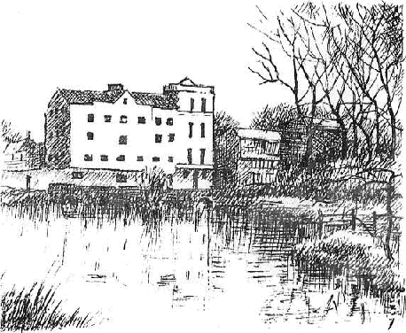
Sudbury Mill
Sudbury has two large areas for riverside walks - one to the west, near "The Croft" and the Mill Hotel and the other to the SE (Friar1 s Meadow) close to the car park near the Railway Station. Near "The Croft" is the weir which holds up the water for the mill stream and one can from here do a pleasant mile-long walk beside the mill race to the Mill Hotel and on beside the tail race to the junction with the Stour at the back of the Boathouse Hotel and then back along the left bank of the main stream. A footpath leads from the Mill Hotel across meadows and river to the "Valley Walk"
There is a pleasant walk eastwards from the end of "The Valley Walk" along the old railway track which crosses first A131 , then the river and then the cut leading to the old Navigation Basin and ends just before the station at the entry to Friar's Meadow .
From the water meadows to the west there are delightful views looking inwards to Sudbury and its 3 church towers St. Gregory's, St. Peter's on the Market Place (now redundant) and All Saints. From Friar's Meadow there are pleasant views looking outwards to the low hills and woods south of Ballingdon Grange. From the western end of Friar's Meadow there is a footpath beside the cut leading to the old Navigation Basin. During the digging of this cut some bones of a mammoth were found and one of the teeth is still in the possession of Mr. Ruse (Ruse and Son, Butchers) of Long Melford. The larger of the Navigation Company's brick warehouses, built in 1791, has been converted into "The Quay Theatre" and the basin is being restored into something like its original state. This basin will have moored in it an old Stour light rescued from Ballingdon Cut opposite and restored at Ballingdon by the River Stour Trust. From the eastern end of Friar' s Meadow a path leads along the river' s left bank, where the meadows are planted with willows, to the site of Cornard Lock. Boat trips are run from the boathouse at Ballingdon Bridge down this stretch of the river.
The 1795 canalisation of the Stour (The Stort was canalised in 1796 and the Chelmer in 1797) had 15 locks and the towpath crossed the river 33 times. The barges were drawn by two horses going upstream and by one horse going down; the journey took 14 hours upstream and 12 hours down. The horses were trained to jump on and off the barges to be ferried across the river when the towpath changed sides. They had also, in the early days of the Navigation, to jump stiles between fields as shown in Constable's picture "The Leaping Horse". Later the stiles were replaced by gates.
The 15 locks were at Cornard, Henny Street, Pitmire, Bures, Wormingford (2), Wissington, Nayland, Horkesley, Boxted, Langham, Stratford St. Mary, Dedham, Flatford and Brantham. There were mills close to all these except Pitmire (near Daws Hall) and Horkesley. Brantham mill was tidal. Barges were poled, sometimes helped by a sail, for the 3 miles between Brantham Lock and Mistley Quay. In 1979 the course of the Navigation is usable only by canoeists prepared to "portage" their canoes at weirs but certain stretches of the river are open to larger craft and boats can be hired at Sudbury, Dedham and Flatford.
The Sudbury to Stratford St. Mary stretch of the valley (there is a full description of this part of the river in The River Stour Trust's "The Essex and Suffolk River Stour - Sudbury to Cattawade Barrage") can best be seen by taking the right bank (Essex) road to Bures, the Suffolk road to Nayland (with short deviations to Wormingford Bridge and Wissington Church) and Essex roads on by Boxted Churchstreet, Boxted Mill and Langham to the Stratford St. Mary bridge and back into Suffolk for the ½ mile to Stratford's waterworks and Swan Inn.
Our journey south from Sudbury starts at Ballingdon crossroads. After ¼ mile, at Ballingdon Grove, we are near the head of the Ballingdon Cut, used in "Navigation Days" for loading chalk. In this cut there are still some hulk relics lying bow to stern where they were moored by the Navigation Company. Some of these were scuttled by the bargees in protest against their loss of livelihood due to navigation ceasing and the rest were sunk in 1914 to prevent their being useful to the enemy should the Germans invade. Barges operated up the river as far as Boxted until 1916 and up to Dedham Lock until 1930.
Some interesting features between Sudbury and Bures are:
For seeing the Cambridge Brook turn right before Bures railway bridge and go for 2 miles or so towards White Colne.
THE CAMBRIDGE BROOK, a 3 mile long Essex stream, rises 1 mile east of Pebmarsh and flows, mostly in a deep valley, S, then E (under the White Colne road), then NE, passing below Mount Bures' superb Norman cruciform church which stands beside the mound of a Norman castle. The confluence with the Stour is just above Bures Mill, but a mile east of the Brook's source.
The undulating left bank road from Bures to Nayland gives excellent views of the valley but we should deviate from it after 1 ½ miles to see the delightful setting of Wormingford Mill House and after another 1 ½ miles to see Wissington (pronounced "Wiston") church. The "Navigation" actually by-passed Wormingford Mill with a 1/3 mile long cut which had on it 2 locks, traces of which still remain. Nearby is Wormingford Mere (private), the home about AD 1400 of an alleged dragon. Wissington Church is pleasantly situated next to the Hall (enlarged by Soane in 1791) and close to the river; it has some interesting 13th century wall paintings in it.
At Nayland ("an island") we go straight on into the town passing close to the former Nayland Lock (hidden by houses) and right, across the mill stream, which makes the town an island, into the main street. The old mill is in 1979 "Mill Stores - Electrical and Grocery" and just after it is Fen Street with a line of old houses each approached by its own bridge over the mill stream. At the southern end of Nayland we cross the main stream of the Stour by Bell Bridge beside which is "The Anchor" where barges used often to spend the night.
Bell bridge, Nayland
This bridge has on its downstream side a keystone carved with a handbell preceded by the letter "A" in commemoration of a 16th century benefactor John Abell. Abell's wooden bridge was replaced by a brick bridge in 1771 and this was replaced by the present bridge in the 195O's. A few yards after the bridge a public footpath to the left crosses the (usually dry) channel below the flood control weir on A134. This path continues down the river's right bank for ½ mile or so to the site of Horkesley Lock (of which no traces remain) and the Boxted road.
On reaching A134 we turn left, cross the flood control weir and after ¼ mile turn left again along a minor road which gives pleasant views of the valley as it climbs up to the Boxted Heights. Interesting features on these Essex roads from Nayland to Stratford Bridge are:
Across the road from "The Swan", 2 mile north of Stratford Bridge, are the Stratford St. Mary waterworks and lock and the large pool with an island in it which used to serve as a parking place for barges visiting the mill. To see the lock one has to walk back along the road for 200 yards to a garage and there turn right by a footbridge over the river. This bridge has to the right a view of the "barge parking place" and then to the left a view of the fine wide river as it flows south from the site of the old mill, which Constable painted, towards the Langham Heights. It was from these, when they were less wooded, that Constable painted his picture "Dedham Vale" in 1828. Towards the western end of the bridge it is possible to scramble down onto a path among trees that leads N along a narrow strip of land between the "barge parking place" and the, lower level, weed-choked approach channel to the lock. The upper approach to the lock, opposite the waterworks, is at present filled in.
6. RIVER BOX (11 miles) and RIVER BRETT (22 miles) |
These two Suffolk rivers, like the Glem and the Chad Brook, join the Stour within a mile of each other. The narrow Box, never more than a couple of yards wide, flows for a short way SW and then flows steadily SE down an ever-deepening valley to join the Stour at Langham. The wider Brett flows SE to Hadleigh and then meanders slowly south to join the Stour at Higham. The Brett has two main headstreams - one from near Brettenham, which makes the river 16 miles long and the other from near Cockfield's Great Green, north of Lavenham, which is 6 miles longer. These two headstreams join at Chelsworth and a mile below this a left bank tributary comes in from Hitcham and Bildeston. A good idea of the valleys of these two rivers can be obtained in making a 38 mile round trip from Stratford St. Mary.
Starting off from The Swan we go to Higham, turn right for a short way along B1068 and then turn left, northwards, by an unsignposted narrow road which gives an excellent view of the valley on the way down from Higham Hill to Lower Raydon. Here we turn left along a narrow lane to Shelley where from the bridge there is a delightful view north at the river meandering through water meadows and west to the church perched up on a ridge. We next continue along the Brett's right bank to Layham Church, after which there is a glimpse of the mill house, and on to Hadleigh's medieval Priory Bridge which is near the site of a former mill. There was in the "canal fever" period of the late 18th century a project to canalise the Brett as far as here. Our road soon reaches B1070 where we turn left along Hadleigh's High Street, a mile-long street with many 14th-16th century houses in it.
Most of the road we have taken from Higham is very narrow. An alternative, though less interesting, route is to go from Stratford St. Mary NE for 2 miles along A12 and then take B1070, which has a number of good views of the Brett Valley, to Hadleigh.
Hadleigh' s Church Street leads left from High Street to the 14th century church with its lead-covered tapering spire, painted by Gainsborough in 1748 when he was 21, its half-timbered Guild Hall dating from 1430 and its 1495 Deanery Tower in which the artist Canaletto executed some of his paintings. It is "Deanery Tower" because the-Rector of Hadleigh is one of the Archbishop of Canterbury's "Peculiar Deans" who are responsible to him and not to the Diocesan Bishop. This arrangement dates from AD 866 when Hadleigh, the capital of the East Angles, was given to the Archbishop of Canterbury.
We go out of Hadleigh by A1071, which crosses the Brett at the northern end of the town. We then travel north by A1141, which gives good views of the river. After a mile is a cross roads with roads leading east to Mill Hill and west to Kersey, one of East Anglia's showplaces and allegedly Suffolk's most photographed village. Kersey gave its name to a coarse woolen material called "Kersey Cloth" and it has a street of beautiful old houses leading down a hill to a watersplash across a tributary of the Brett and up the other side to the church on its 177' hill.
Half a mile beyond the cross roads we keep straight on onto B1115 which from a hill of nearly 200' gives a superb view of the valley. At the foot of this hill just before road crosses river at a height of 91 ' is a turning to Semer Church which stands among trees on the green valley floor close to the river and at the foot of a steep wooded hill. B1115 follows closely the Brett and then the "Bildeston Brook" for the 1 ½ miles on to Bildeston's fine market square dominated by the Georgian "Old Rectory". From Bildeston B1115 takes us W over a ridge to the Brett and Chelsworth, another showplace of old houses and some beautiful park land by the river near the church, and on to Monks Eleigh with its pretty little Green lined by 15th-16th century houses leading up to the church.
At the western end of Chelsworth B1115 crossed the Brettenham headstream of the Brett and it then ran up the valley of the Cockfield stream, the larger of the two. We now return to the eastern end of Monks Eleigh and turn right for a short way down A1141 to see the Cockfield stream at the site of a former mill. We then go north along a narrow road that gives some good views of the Brettenham stream. After Preston we turn right and after \ mile cross the river which is here in a deep valley. At the gates of Brettenham Hall, now a school, our route turns left but we might first go on for 2 miles to Brettenham Church which has in it a "Vinegar Bible" of 1716 with the word "Vinegar" instead of "Vineyard" in the heading to St. Luke Chapter XX. From Brettenham Hall we go west to Thorpe Morieux (pronounced "Mroo"), cross the river by its first road bridge and after this get a view across a field of the church's fine Perpendicular tower.
From Thorpe Morieux it is 2 miles NW to the "T" junction with the Felsham to Cockfield road which is close to the source of the Cockfield headstream. We turn left here for Great Green, one of Cockfield parish's 8 greens, whose triangular Green really lives up to its name. At Cockfield we should, before crossing the river, take the lane to the right to the church that is beautifully situated close to old houses and a pond. On reaching A1141 we turn left for Lavenham. This road gives good views of the valley to the left and of the 141 ' high tower of Lavenham's 1468-1525 church to the right.
At Lavenham we should, if we have already seen "the sights", turn left at the old station and then right to follow the river as it skirts the eastern edge of the town, and then rejoin A1141 for the 2 miles on to Brent Eleigh. ("Eleigh" means "Ilia's Wood"; "Brent" refers to a fire sometime before 1254). Here we look across the valley to the fine early 18th century Hall, which has the church beside it. We are now but 1 ½ miles from Monks Eleigh which we visited coming up so we turn right and then right again, along B1115, for Little Waldingfield, which stands oon a ridge between the two main headstreams of the Box. We cross the northern headstream soon after the village and ½ mile after this turn left for Great Waldingfield Church, which contains carved woodwork brought from St. Michael's, Cornhill and. is beautifully situated among trees and old houses. We continue along the right bank past Badleys (good view-) for 1 ½ miles and cross the Box in an attractive setting at Brook House. Edwardstone Church, 2 miles on along the left bank, is on a hill overlooking the valley which here boasts a Roman Ford. The church was elegantly restored and contains some very attractive "furnishings"; it is approached through the 1840 arch and up the drive of the Hall which was demolished about 1950.
From the arch we go E for 1 ½ miles to Broad Street to see something of the Box's principal tributary (which joins the river at Boxford) and then S to Groton Church with its memories of Jn Winthrop. John Winthrop b 1588 became Lord of the Manor in 1618 and in 1630 led the great Puritan Emigration to New England, where he founded Boston and became the first Governor of Massachusets. Winthrop descendants in U.S.A. have given the church an east window (in memory of John Winthrop), lighting and heating and have paid for tower and roof repairs.
Boxford is the Box's showpiece and its splendid church (which has in it a tablet commemorating Elizabeth Hyam who died in 1748 in her 113th year) looks down onto a row of lovely old houses ending in the Mill House. The site of the mill is now occupied by the doctor's surgery.
We take A1071 SE to Calais Street and secondary roads on to Polstead whose church next the Hall stands on a ridge with views south across the Box's deep valley to the magnificent 120' 15th century brick tower of Stoke-by-Nayland church (painted by Constable from the other side) and north onto a large pond. There is a story that a conscientious postman, thinking that recipients "would be disappointed by the small amount of medicine arriving in the bottles he delivered, filled the bottles up with water from the pond. The results of this "good deed" are not known. Polstead church has brickwork round its Norman arches; Anglo-Normans made their own bricks here as they did at Coggeshall.
Our road continues down hill for ½ mile to cross the Box just below the old mill and then climbs quite steeply for another ½ mile up to the delightful village of Stoke-by-Nayland which stands on a ridge between Box and Stour. Stoke-by-Nayland' s church is probably the most exciting of the Stour's five large 15th century churches, the four others being Clare, Long Melford, Lavenham and Dedham.
B1068 takes us from Stoke-by-Nayland back to Higham, After 2 miles we cross the Box at Thorington Hall and we cross the Brett a mile later just short of Higham. The Box is still a narrow stream; the Brett is a sizable river. A short way up the lane beside Thorington Hall (built 1600-1700) is a delightful little mill with mill house and mill pool in a deep valley.
At Higham' s small triangular Green we turn right and soon pass near the Church and the Hall which are close to but do not give access to the Brett-Stour confluence. From here it is but a mile back to "The Swan" at Stratford St. Mary.
7. STRATFORD ST. MARY (27') TO CATTAWADE |
4 miles |
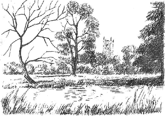
Dedham
For this final section we return along the old A12 into Essex, take the right-bank road (which gives good views of the valley) to Dedham, B1029 back into Suffolk and Stratford St. Mary Church, A1 2 eastwards for ¼ mile and then secondary roads to East Bergholt Church and on to Flatford Mill. On returning to East Bergholt Church we turn right for B1070 and along this to Cattawade.
Immediately above Stratford's 1926 bridge is "Le Talbooth" restaurant, the oldest part of which was at one time a toll booth; below is the elegant 1966 bridge of the new A12. There are walks along both sides of the river from here to Dedham. The Suffolk path goes along the left bank to Dedham Lock, mill pool and bridge; the Essex path starts at the Dedham Vale Hotel, follows the right bank for a short way and then crosses fields with views ahead to Dedham1 s magnificent 130' tower. These two paths give a pleasant circular walk of some 2 ½ miles. There is also a pleasant 3 mile circular walk from Dedham to Flatford Mill and back. From the entrance to Dedham Hall at the eastern end of the village a path leads across fields to the river and then along the right bank. From Flatford go up the East Bergholt lane for ½ mile and then take a track down to Fen Bridge and from there a path leading westwards across fields and on along the left bank back to Dedham bridge.
Where the right bank footpath reaches the river is the start of the Stour's "Delta" and from here there are two streams - the northern "freshwater reservoir stream" which flows past Flatford and Brantham to Cattawade Barrage and the southern "land drainage/floodwater control" stream which flows to Cattawade Sluice. At Judas Gap the southern stream flows through "Fifty-Six Gates", a battery of tide-flapped sluices, into the tidal channel and the northern stream discharges surplus water over a weir (which has a fish pass in it) into the tidal channel. Cattawade Sluice controls the amount of seawater coming in and the amount of flood water going out. The county boundary follows the southern stream to Judas Gap and then the northern stream.
There is an excellent walk of 2 miles from Flatford to Cattawade Sluice - first along the right bank of the northern channel, then across "Fifty-Six Gates" to the right bank of the southern channel. One can then walk a mile along roads via Cattawade Barrage to Brantham Mill and return by the mile-long north bank footpath across fields (from which there is a good view of the remains of Brantham Lock) to Flatford.
The 18th century bridge of the old A137 at Cattawade is now for pedestrians only and there is from this a pleasant view seawards to the barrage with its rollers for hauling small craft over to the tideway and of the beginning of the estuary behind it. From the barrage one can look back at the elegant 3-arch brick bridge and the beginning of the "East Bergholt Heights".
8. THE ESTUARY |
For seeing the northern, and quieter, shore of the estuary take A137 from Cattawade, then B4O80 (crossing the 8-mile brook which rises 2 miles E of Hadleigh and joins the estuary at Stutton Mill) to Holbrook Mill, then secondary roads by Harkstead and Erwarton to B1456 and Shotley Gate. There are walks down to the estuary from Brantham Church (which has in it a picture by Constable of Christ blessing little children), Lower Holbrook and Harkstead; the road itself, just before Erwarton, gives superb views over the estuary. B1456 ends at the "Bristol Arms" (a pleasant place for a meal) on the waterfront facing Parkeston Quay. From here a path along the sea wall leads in ½ mile to Shotley Point from which we look S across the Stour to Harwich, E across the Orwell to Felixstowe and SE down Harwich Harbour to the sea.
Of interest beside this northern-shore road are the fine buildings of the Royal Hospital School, for sons of officers and men of the Royal Navy and Royal Marines, transferred from The Queen's House at Greenwich to Holbrook in 1933, and the 1575 Erwarton Hall with its quaint James I gateway.
The best views of the southern shore of the estuary are from the Manningtree-Harwich railway but if we are travelling by car we take A137 from Cattawade to Manningtree Station, B133 to Manningtree, Mistley andRamsey and A604 to Harwich. At Manningtree ("Many trees") the waterfront has a fine view across the head of the estuary and its large number of swans to the Cattawade industrial complex opposite. At Mistley ("wood where mistletoe grew") is a delightful "parade" with trees and lawns beside the estuary and later the magnificent Maltings buildings at the quay.
B1352 gives several good views of the estuary but we should turn left at Wrabness' "Wheatsheaf" for a short detour past Wrabness Church, Hall and Railway Station. There are footpaths to the estuary west and east of the church. The first gives a superb view up the estuary towards Mistley and across it to the Royal Hospital School at Holbrook and the second has good views downstream towards Shotley.
To see something of the Stour's last tributary THE RAMSEY BROOK turn right at Ramsey and drive west along A604 to Wix Green, SE to Great Oakley and NE along A136 back to A604. Great Oakley has a quaint looking church with weather-boarding on its tower pleasantly situated looking down on to the Brook and it has, for a village, a remarkably spacious square. A1 37 gives good views across Hamford Water to. The Naze. The end of the Brook can be seen from the road leading to Parkeston Quay.
A604 ends at Harwich Pier. From here we can complete our journey with walking through Harwich' s old streets (Harwich was one of the first towns to be laid out on the grid principle) to the 1821 church and then past the old light house and along the sea wall to the harbour mouth.
Index |
| Ballingdon | Flatford | Ramsey | |
| Baythorne End | Glemsford | Rede | |
| Belchamp | Groton | Rodbridge | |
| Bildeston | Hadleigh | Semer | |
| Boxford | Hartest | Shimpling | |
| Boxted (Sfk) | Harwich | Shotley | |
| Boxted (Ex) | Haverhill | Sipsey Bridge | |
| Bradley | Henny | Stoke-by-Nayland | |
| Brantham | Higham | ||
| Brent Eleigh | Holbrook | Stradishall | |
| Brettenham | Kedington | Stratford St Mary | |
| Brockley | Kersey | ||
| Brandon | Kirtling | Sturmer | |
| Bumpstead | Lamarsh: | Sudbury | |
| Bures | Langham | Thorington | |
| Cavendish | Lavenham | Thorpe Morieux | |
| Cattawade | Liston | ||
| Chedburgh | Long Melford | Thurlow | |
| Chelsworth | Manningtree | Waldingfield | |
| Clare | Mistley | Wickhambrook | |
| Cockfield | Monks Eleigh | Wissington | |
| Dedham | Nayland | Withersfield | |
| Denston | Oakley | Wixoe | |
| Edwardstone | Pentlow | Wrabness | |
| Erwarton | Polstead | Yeldham |
ACKNOWLEDGEMENTS |
River Stour Trust's "The Essex and Suffolk River Stour". (an Inland Waterways Association Publication)
"The Lower Stour - A Guide to Dedham Vale" edited by T. Palmer, VV. H. Downes and D. Hawes.
"The Stour Valley by Car" by P. and H. Titchmarsh (Jarrold)
"The Suffolk Stour" by Ambrose Waller (1957:. out of print)
"Seven Parishes of North Essex" by Montgomery Burnett.
"Groton, Suffolk" by The Rovd. A. B. Bird.
Norman Scarfe's "Shell Guides to Essex and Suffolk" (Faber) Arthur Mee's
"The King's England - Essex" (Hodder & Stoughton)
P. G, M. Dickinson's "The Little Guides - Suffolk" (Methuen)
and the help received from the Environment Agency and Anglian Water-then
the Anglian Water Authority (Essex River Division) at Glelmsford, The
River Stour Trust and from all those who have been so patient in
answering questions.
Map of district reproduced from the Ordnance Survey map with the sanction of the controller of H.M. Stationery Office. Crown Copyright Reserved.